| Location | General | Staff and Contact | Environment |
| Data | Climate | Measurements | Facilities |
Location
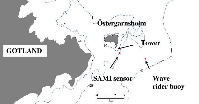
The measurement site is about 4 km from the eastern coast of Gotland located on Östergarnsholm which is a small, flat island which stretches about 2 km in a W-E and N-S direction respectively. The maximum depth of the sea within 1 km radius is about 30 m. The WGS84 coordinates (Latitude, Longitude) of the measurement installations are:
30 m tower: 57.43010 N, 18.98415 E
SAMI and Seabird sensor: 57.42333 N, 18.99450 E
Wave buoy (operated by FMI): 57.41667 N, 19.05333 E
General
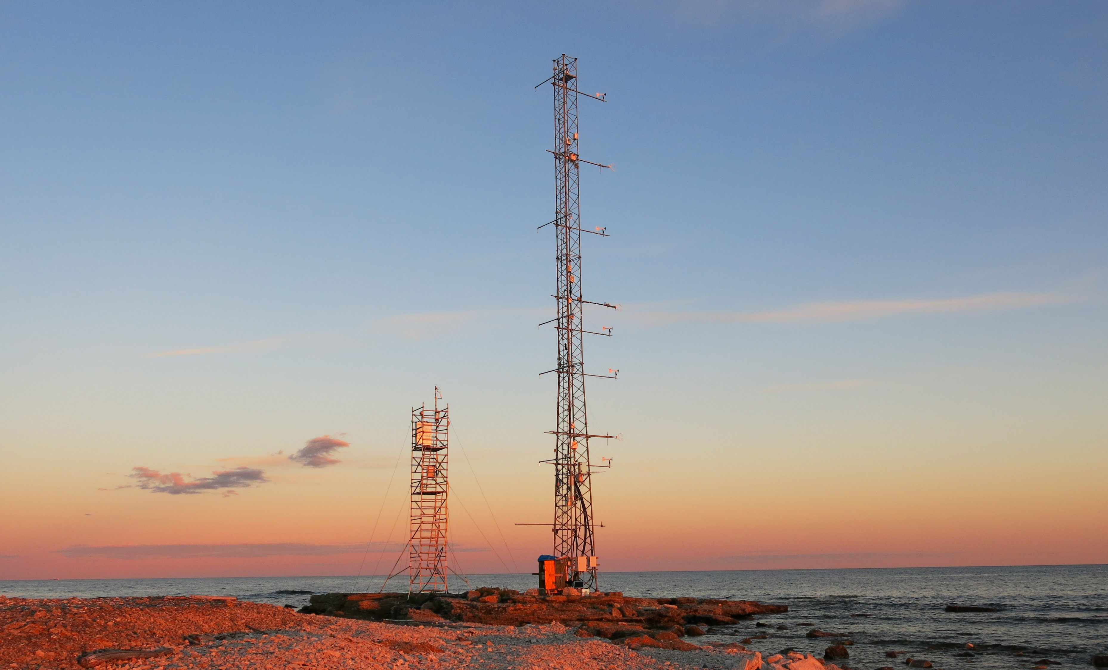
On the island Östergarnsholm located about 2 nautical miles off the east coast of Gotland a 30 m micrometeorological tower was established in 1995 on the most southern tip of the island. The research site hosts a ICOS fixed Ocean station (FOS). The station includes land-based measurement of turbulent exchange of momentum, energy and carbon between surface and atmosphere, but also water-based measurements on surface water pCO2 and other important state variables (see more below).
The research site also hosts a stations for the national infrastructure ACTRIS Sweden.
Staff and Contact
- Ocean station SE-MFT-Östergarnsholm PI: Anna Rutgersson
- research engineers: Erik Nilsson; John Prytherch
contact: ostergarnsholm@icos-sweden.se

|

|
Environment
Östergarnsholm is a small, flat island which stretches about 2 km in the W-E and N-S direction respectively. The southern part is very flat and rises only a few meters above sea surface.
The island is small and flat covered by small rocks and pebbles. The vegetation on the island consists of a few single trees (mainly in the N-E corner) as well as low herbs and grass together with small bushes.
Data
Currently, the marine pCO2 data from Östergarnsholm (2005-2000) is only available through the SOCAT database. But it will also be available through the ICOS Carbon Portal as soon as the labelling process is finished. Data for 2021 and 2022 has been submitted, but was not processed yet by SOCAT.
Climate
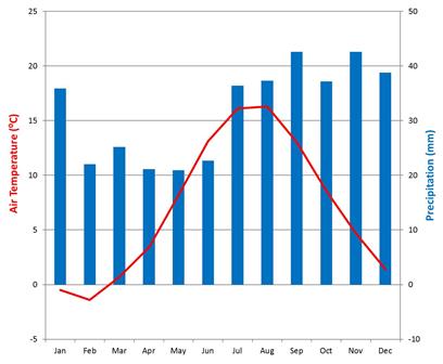
With a mean annual air temperature of 7°C and a mean annual precipitation of 383 mm (data period 1961-1990, SMHI station Östergarnsholm) the climate is characterized after Köppen as a Cfb-climate, i.e. humid temperate with mild summers and mild winters.
The cold water in spring and summer gives dominantly stable atmospheric stratification during April to July. Despite low winter temperatures, the sea surrounding Östergarnsholm has ice free conditions throughout the year. Higher rates of cyclonic activity in winter result generally in higher wind speeds in winter than in summer.
The carbon cycle represented by the Östergarnsholm site shows a strong seasonal variation with marine carbon uptake from April to October, and emissions from November to March. Algae blooms with resulting biofouling on water-side sensor is fairly common in summer time.
Measurements
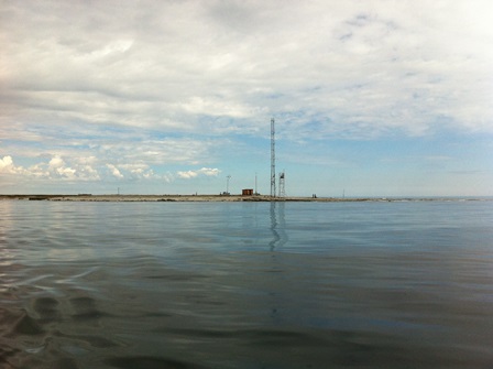
A 30 m tall tower is situated around 1 m above sea level on the southernmost tip of the small flat island Östergarnsholm. Two buoys are located 1 km (SAMI sensor) and 4 km (Wave rider buoy) southeast of the tower, respectively.
Measured Ocean station variables
Variables included in the Ocean station program at the fixed Ocean-marine flux tower station Östergarnsholm are listed on the Ocean station introduction page: follow this link to the table
Water-side measurements are taken using several different sensors semi-continously during active deployment periods. These measurements include sea surface temperature and profile measurements of temperature and conductivity (measured as proxy for salinity) at depth ranging from about 0.5 to 20 m. Also measured are carbon dioxide (pCO2), oxygen, pH, Chlorphyll, Turbidity and fDOM as well as wave parameters in collaboration with Finnish Meteorological Institute (FMI). Discrete manual water side measurements and sampling include Phosphorous (TP, PO4), Nitrogen (TNm, NH2, NO3+NO2) and Silica (DSi).
Atmospheric measurements on the site includes 3D wind speed with sonic anemometers, eddy covariance measurements of CO2, H20 and heat fluxes. There is a gradient system for CO2 and H20 at the site and propeller anemometers and thermocouples in the 30 m tower. Relative humidity, atmospheric pressure, global radiation and precipitation is also measured on the site. During different time periods other parameters have also been observed such as methane, oxygen and clouds.
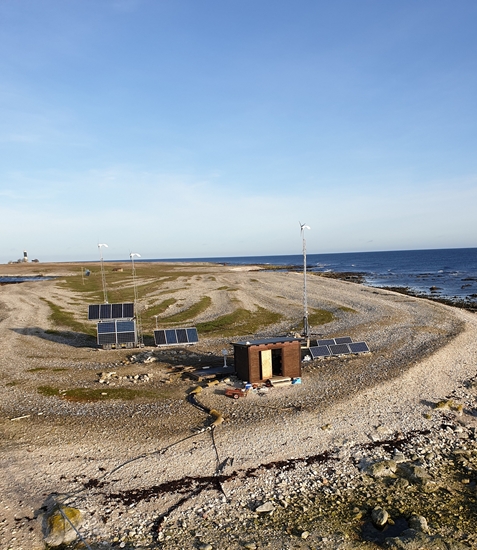
Facilities
ICOS Östergarnsholm welcomes individual researchers and research groups to come to the measurement site and use existing infrastructure for their own measurements and collaborations.
There is no grid power on Östergarnsholm but the site has its own power supply consisting of wind turbines, solar panels and a backup diesel generator owned by Uppsala University and monitored by an external company. It is an autonomous system delivering 12 V, 24 V and 230 V. The total electricity capacity available on the site is about 2.5kW (in operation since November 2016). The diesel generator is placed approximately 400 m north from the measurement tower (close to the old harbor) to minimize influence on the measurements.