Location
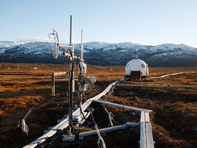
The Abisko-Stordalen Palsa Bog ICOS Ecosystem station (SE-Sto, 68°21′N, 19°03′E, 360 m asl) is located within the sporadic permafrost zone, adjacent to lake Torneträsk. A large portion of the mire consists of a slightly elevated drained area, altered by wetter depressions, which are not underplayed by permafrost.
General
The Abisko area has a long lasting history of climate and vegetation research going back to the 1970s. It is located on the 0°C isotherm which causes the permafrost in the mire to be of sporadic and of very dynamic nature. As a result of recent years warming in the area permafrost has been observed to degrade in many parts of the mires. Abisko is also part of the national infrastructure SITES and the INTERACT Trans National Access project. The station received the ICOS label as Class 2 Ecosystem station in May 2022.
Staff and Contact
Ecosystem station PI: Erik Lundin
other station personnel: Niklas Rakos
contact: stordalen@icos-sweden.se
Data download
Pre-ICOS (2014-2021) data from the ICOS station Abisko-Stordalen palsa bog (SE-Sto) can be downloaded from the ICOS Carbon Portal as Swedish National Network data. Quality controls, eddy-covariance flux calculations, gap-fillig, and flux separation in these data sets have been done by ICOS Sweden. The data from this dataset should be cited as follows: ICOS Sweden, 2023. Collection of Abisko Stordalen Palsa Bog Swedish network data. https://doi.org/10.18160/Q6H6-B94B
Final quality controlled ICOS Level2 data from Abisko-Stordalen mire (SE-Sto) can be downloaded from the ICOS Carbon Portal.
ICOS level 1 data (near real time, not finally quality controlled): preview on Carbon Portal
Data gathered through the RI SITES is available at the SITES data portal: Stordalen mire, Abisko Scientific Research Station
Climate
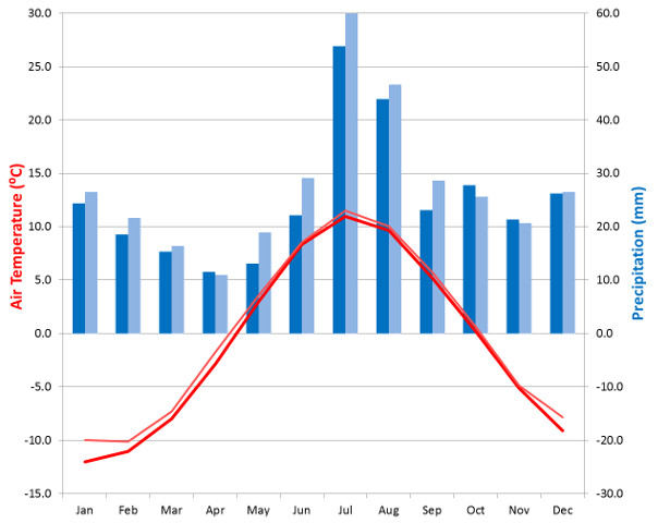
The Köppen climate classification characterizes the climate in Abisko as humid subarctic with cold summers and cold winters. The annual mean temperature in Abisko is -0.1°C (data period 1981-2010) with increasing temperatures over the last decades (for the 1961-1990 normal it is -0.9°C).
The location is characterized by belonging to the driest regions of Sweden with a mean annual accumulated precipitation of 332 mm (data period 1981-2010, 10% more compared to the 1961-1990 normal). The low amount of precipitation has profound effects on the palsa features found on the mire.
The length of the vegetation period (i.e. days with a daily mean temperature above 0.4°C) is slightly longer than three months.
Measurements
Measured Ecosystem station variables and summary of station parameters
Variables and measurement heights included in the Ecosystem station program at Abisko-Stordalen Palsa Bog are listed on the Ecosystem station introduction page: follow this link to the page
Non-ICOS measurements
Abisko Research station is part of SITES. Stordalen mire(and the adjacent birch forest and lakes) are intensively used by many national and international scientists, e.g. for N2O flux measurements or spectral measurements to calculate different vegetation indices at the site. For more detailed information please contact the station.
Geology and Soil
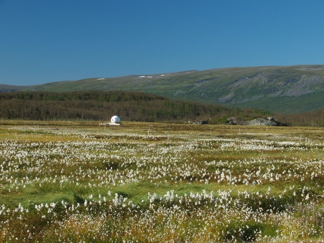
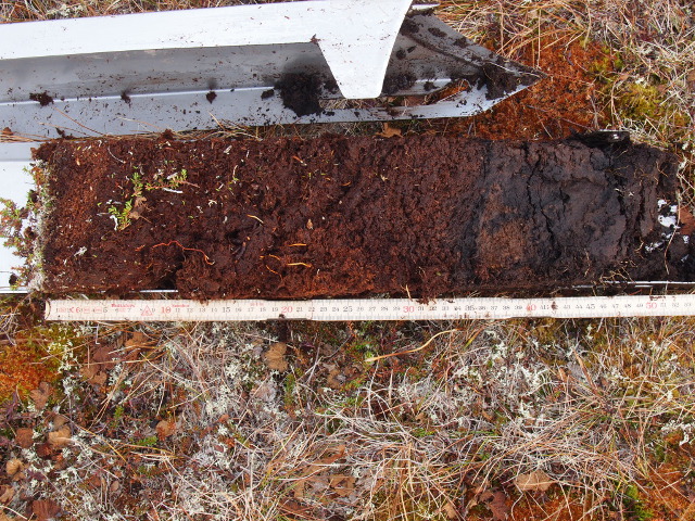
The site represents a subtype of sub-arctic wetlands, characterized by palsas. Peat depth is 1-3 m and permafrost is usually found at depths below 0.5-1 m. The soil is organic, with 99% organic matter content.
There are three different main types of surface structures:
- dwarf shrub-dominated palsas,
- moss Sphagnum dominated hollows, and
- cottongrass Eriophorum and sedge Carex dominated hollows.
Vegetation
The peatland in Abisko-Stordalen Palsa Bog is fed only by precipitation, i.e. it faces ombrotrophic conditions. Depending on soil water content and microtopography, the plant community structure and composition varies between:
- Dry ombrotrophic parts are dominated by crowberry Empetrum hermaphroditum, lingonberry Vaccinium vitis-idaea and cloudberry Rubus chamaemorus;
- semi-wet ombrotrophic parts by the sedge Carex rotundata and the cottongrass Eriophorum vaginatum; and
- wet minerotrophic areas by the cottongrass Eriophorum angustifolium.
Foliar analyses | |||||||||
|---|---|---|---|---|---|---|---|---|---|
sample type: Eriophorum vaginatum: leaves; Sphagnum: plant concentration in sample dried at 65°C dry mass ratio: (dry mass at 103 °C) / (dry mass at 65 °C) | |||||||||
| parameter | species | 2018 | 2019 | 2020 | 2021 | 2022 | 2023 | 2024 | 2025 |
| Ca (g/kg) | Eriophorum vaginatum | 1.45 | 1.20 | 1.34 | 1.26 | 1.10 | 1.07 | 1.46 | 1.39 |
| Sphagnum | 1.32 | 0.77 | 0.86 | 0.76 | 1.78 | 1.57 | 1.88 | 1.60 | |
| Cu (mg/kg) | Eriophorum vaginatum | 3.00 | 2.73 | 3.06 | 2.93 | 4.11 | 3.42 | 3.45 | 3.31 |
| Sphagnum | 2.73 | 1.62 | 3.29 | 1.63 | 3.09 | 2.60 | 3.27 | 2.68 | |
| Fe (mg/kg) | Eriophorum vaginatum | 97.05 | 111.94 | 72.98 | 63.01 | 63.05 | 63.56 | 50.36 | 88.12 |
| Sphagnum | 413.0 | 1099.2 | 1049.6 | 667.3 | 1137.3 | 1994.3 | 5242.8 | 3009.5 | |
| Mg (g/kg) | Eriophorum vaginatum | 1.76 | 1.16 | 1.22 | 1.20 | 1.37 | 1.23 | 1.33 | 1.31 |
| Sphagnum | 1.09 | 1.01 | 1.12 | 0.92 | 1.24 | 1.11 | 1.46 | 1.20 | |
| Mn (mg/kg) | Eriophorum vaginatum | 160.0 | 63.4 | 61.7 | 82.5 | 72.7 | 99.7 | 71.3 | 62.0 |
| Sphagnum | 84.1 | 48.4 | 57.2 | 48.4 | 103.5 | 70.6 | 94.3 | 66.0 | |
| C (g/kg) | Eriophorum vaginatum | 482.7 | 488.6 | 493.3 | 492.0 | 482.8 | 486.3 | 494.1 | 483.5 |
| Sphagnum | 467.8 | 466.1 | 474.0 | 472.0 | 475.6 | 471.5 | 477.7 | 469.0 | |
| N (g/kg) | Eriophorum vaginatum | 14.02 | 14.31 | 19.03 | 17.49 | 14.61 | 12.85 | 15.41 | 17.85 |
| Sphagnum | 9.72 | 10.26 | 11.25 | 9.87 | 8.28 | 9.01 | 10.21 | 9.52 | |
| P (g/kg) | Eriophorum vaginatum | 1.85 | 1.90 | 2.16 | 1.96 | 2.35 | 1.61 | 1.94 | 2.08 |
| Sphagnum | 0.97 | 1.33 | 1.56 | 1.50 | 1.21 | 1.32 | 1.59 | 1.38 | |
| K (g/kg) | Eriophorum vaginatum | 5.61 | 6.99 | 6.53 | 6.77 | 7.62 | 6.59 | 6.80 | 6.49 |
| Sphagnum | 4.47 | 6.38 | 7.50 | 7.21 | 5.14 | 5.14 | 4.45 | 4.24 | |
| Zn (mg/kg) | Eriophorum vaginatum | 61.0 | 31.5 | 39.0 | 36.6 | 36.86 | 32.43 | 39.58 | 34.22 |
| Sphagnum | 37.0 | 30.6 | 22.0 | 21.8 | 24.95 | 19.46 | 32.87 | 19.86 | |
| dry mass ratio (%) | Eriophorum vaginatum | 90.88 | 91.51 | 91.38 | 89.51 | 91.75 | 93.16 | 91.21 | 91.52 |
| Sphagnum | 87.71 | 88.16 | 87.20 | 85.23 | 90.44 | 90.13 | 88.89 | 89.45 | |
Facilities
The Abisko Scientific Research Station (ANS) and SITES are managing access to facilities in the Abisko region. Please, check their webpages for more information on available facilities.
References
- Lakomiec P, J Holst, T Friborg, P Crill, N Rakos, N Kljun, P-O Olsson, L Eklundh, and J Rinne, 2021.Field-scale CH4 emission at a sub-arctic mire with heterogeneous permafrost thaw status. Biogeosciences. doi:10.5194/bg-18-5811-2021
- Faucherre et al., 2018. Short and Long-Term Controls on Active Layer and Permafrost Carbon Turnover Across the Arctic. JGR Biogeosciences 123, 372-390. doi:10.1002/2017JG004069
ICOS ETC labeling report: